 |
| These trees are usually on a dry sand bar. |
Note! Click on photos to view full size.
Location: N40º 31.612’ W79º 50.747’
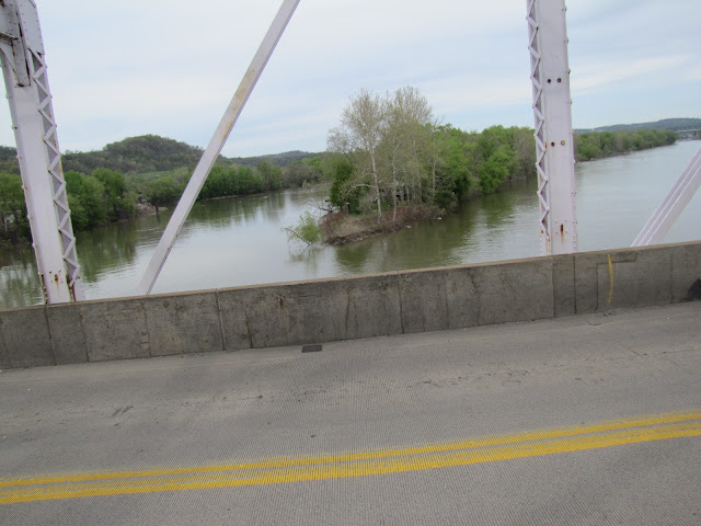
This is another, how shall we say, screwing off instead of chores post. I am hoping to make that a hallmark of my retirement. "Well he is supposed to be out cutting the grass, but he is probably taking pictures of some railroad crossing for that stupid blog." On Saturday, April 30th, I had packed my camera in the car to go cut grass at my mother-in-law's house in Monroeville. Curious tool for cutting grass, I know, but I wanted pictures of the Union RR roundhouse turntable before the trees are fully leafed. Well somehow you have to get across the Allegheny River, so around here that means you either cross on the turnpike for a fee or use the Hulton Bridge at Oakmont for free. Free yes, but you burn a lot of gas sitting at lights. The turnpike is probably a deal as long as you are willing to drive to Monroeville, the first exit east. I despise the turnpike, and it has its own set of lights at the Monroeville end. Anyhow, the water has been high this year on the rivers, but having been a working stiff, I always crossed over the bridge in the dark or in a hurry. I don't ever recall of being in a hurry to cut grass so when I saw the high water, I thought what the hell stop and get some pictures. You gotta take pictures of high water when it is high. Parking at the Riverview High School parking lot, I managed to take these pictures. The water has been higher, and it certainly is not flooding, but this is still higher than normal.
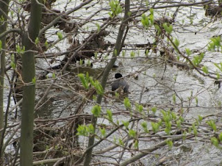 |
| American Coot |
The first photo above is looking down stream from the bridge. Those trees are usually sitting on a dry sandbar. Well that is it for the high water photos, but damn, I was still in no hurry to cut grass. I love the Hulton Bridge so mizewell (Pittsburghese for may as well) get some photos of the bridge while I was there. As I walked toward the bank, I rousted out a water bird which I have never seen before. Very white bill, black head and a slate gray body. Very shy, it kept a bush between us so I could not get a good photo. My brother-in-law, the naturalist, ID'd it as probably an American Coot from my description, and I verified it with Google images. One for my life list. At full size you can barely see the black spot on the end of its bill.
The Cornell Lab of Ornithology calls this a "swimming rail" not a duck. So it turns out the old coot got to see an American coot.
 |
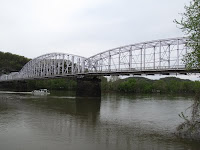
| The Jonathan Hulton Bridge, Subdivided Parker Pratt Though Truss, 1544 Feet Long, Built in 1908 |
Well there it is. The Jonathan Hulton Bridge, the official name, which seemed to undergo some political shenanigans of which I will not go into but you can read about here on the wonderful
Pittsburgh Bridges.com, Hulton Bridge webpage. No your eyes are not deceiving you, it is a slightly lavender shade. It had something to do with how the paint was mixed during the last refurbishment in the early 90s. I read some place, at the time, that the paint was a special formulation to show cracks.
 |
| A Gibson Underway |
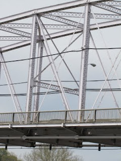 |
| Truss Detail, Note Links Under The Deck |
|
|
|
 |
| Massive Stone Abutment |
Note the massive stone abutment in the photo. The piers are also made of stone. Give me those any day compared to the spindly prefab piers that they used on the new turnpike bridge.
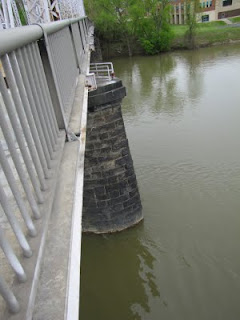 |
| Stone Pier |
 |
| East Approach |
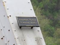 |
| Politically Troublesome Name Plate |
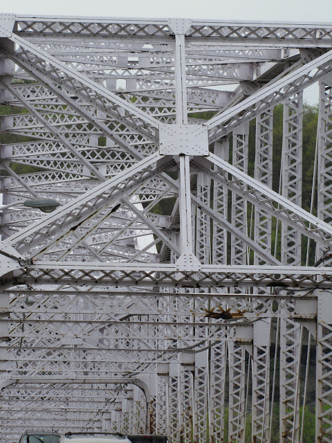 |
| Zoom of the superstructure. It is rated, sort of like me, structurally deficient. |
 |
| View Down Stream |
|
|
The photo above is the view down stream. If you look to the right you will see one of our famous sliding hills. The road cut for PA 28 South goes through typical south western Pennsylvania sedimentary rock, shale, coal, Ames limestone, and sandstone. All crap laid down 300 million years ago in the Pennsylvania period. There isn't a decent piece of rock to be found in Allegheny County. It is nothing but dried and hardened mud. As a result we have a lot of rock slides on that cliff.
 |
| Zoom in on the nun. |
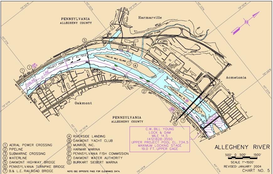
The object in the water is a navigation buoy called a nun. They are red with a pointed top and mark the left side of the navigable channel when looking down stream. The Allegheny River is navigable up to a town called East Brady. The navigable channel is maintained by a series of lock and dams located about 9 miles apart. These create a series of slack water deep pools which the Army Corps of Engineers maintains at a guaranteed depth of 9 feet for river navigation. Each dam raises the river level about 10 to 15 feet higher than the previous pool down stream. The pool elevation (on average, it is higher now) in Pittsburgh is 710 feet, maintained by the Emsworth Lock and Dam on the Ohio River. Lock and Dam # 2 at Highland Park raises that level to 721 feet. About 2 river miles upstream the C. W. Bill Young (to me its just # 3--I don't go for all this political ass kissing in the naming of public objects) Lock and Dam raises the river level to 734.5 feet. These are called project pool elevations. The Corps of Engineers have the navigation charts in PDF files on the web at
U.S. Army Corps of Engineers, Allegheny River Navigation Charts
I screen dumped this one showing the pool at the Hulton Bridge. Click on it to view it full size. Item number 5 is the Hulton Bridge. The nun is shown immediately to the left of the bridge on the edge of the navigable channel (white area). Item 6 and 7 are the Turnpike and the Bessemer and Lake Erie RR bridges. Lock & Dam # 3 is denoted by the box with the purple print. Note that north is skewed about 45 degrees clockwise as indicated by the arrow and the latitude and longitude grid. Below is the symbol key, another screen dump of the Corps of Engineers PDF converted to JPG.
EDIT 5-3-2011: I just realized how difficult it is to see the nun in the above chart. I blew it up, touched it up with a brighter shade of red and placed an arrow on an inset of the chart.
 |
| Oh no, this is for the Mon, are they the same for the Allegheny? Yes. |
I love these charts. I am glad that the Corps of Engineers put them back up on their web site. They had removed them for a while after 9-11, as if no one would be able to commits acts of terror on the river without them. Below is a screen dump of roughly the same area in a satellite photo from Google Maps. North is straight up on this image. The Lock & Dam is in the upper right corner, the Hulton Bridge is in the lower left marked with the A.
Image Credit Google Maps, Hulton Bridge
 |
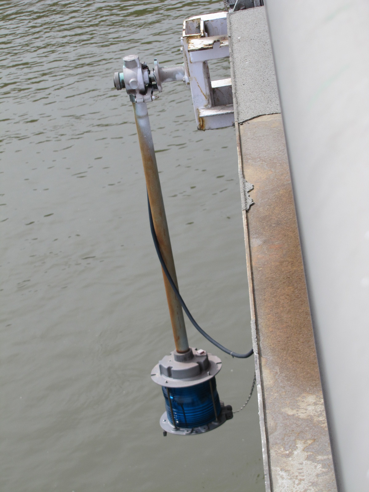
| Green Navigation Light Marking Mid Span |
I am losing track of the trees for the forest. Lets get back to the bridge, well actually more navigation aids. It is a real aid to navigation to not hit the bridge piers with your boat at night. So the U.S. Coast Guard maintains bridge lights. Go under the green light and you are mid channel and safe. The red lights are mounted on the piers. Note the chain on the light. That is for rotating the light fixture upward to the bridge deck to change the bulb. The light post is mounted on an axle. The globe looks blue in the photo and to my eye, but it is green at night.
 |
| Red Navigation Noting Location of the Bridge Piers |
The red pier light has a shield in the back to keep the glare off the bridge.
 |
| The Highest Section of The Truss, Mid Span |
 |
| Looking Upstream |
If you view the photo full size you will note small object in the water. These are the green navigation buoys with a square or slightly round top called cans. The green cans mark the right side of the navigation channel looking down stream. Because we are looking upstream, the cans are on the left side of the channel.
 |
| Zoom In Upstream |
|
|
The above photo is a zoom of upstream. The Bessemer & Lake Erie Railroad bridge is visible. The white ribbon in front of it is the new (and in my mind junky) prefab concrete Pennsylvania Turnpike bridge. Again the green can navigation buoys are visible in the water.
 |
| 12 Mile Island |
On weekends, cross the bridge and you can park here at the high school parking lot and explore this bridge. There is a side walk on the downstream side of the bridge that goes the whole way across the bridge. Riverside Park is adjacent to the High School on the downstream side.
And saved for last, my great discovery!
 |
| Click it, then click it again to see the Carnegie imprint right in the middle. |
 |
| Crappy Photo Of The Northern Pike Bridge |
One of my holy grails in life is to find Carnegie marked on a steel beam. My father claims to have seen this on the bridge down in the woods where the old Northern Pike crossed Thompson Run. I searched that bridge and I could not find any indication of Carnegie. Someone told me it could be seen on the Hulton Bridge. Wow, I found it, and once you find the first one, you will note them all over the place. So what is the big whoop?
Carnegie Steel became United States Steel in 1901. The bridge was built in 1908 so it was either made with older steel or USS had not changed the imprint. So there you have it, a logo from yester-year that will slowly disappear as time goes on. Anyhow, having searched the Northern Pike Bridge several times for Carnegie and always failing, it was a great find on the Hulton. It will be added to my life list as well. Unlike birders my life list has all sorts of mayhem on it, LSTs, galaxies, and now a logo from an old steel company.
Photos on Saturday instead of cutting grass, blogging on Monday instead of working...what was my objection to retirement?


OK..so what's up with the 12 and 14 mile islands. I see by the satellite photo, there are houses or cottages on there.? What's up with that? They must get flooded out from time to time.?
ReplyDeleteThe Northern Pike Bridge...some Wabi-sabi happening there..how old is that bridge? So maybe the Carnegie imprint will still be found on that old bridge.
Toll roads and bridges...bah...wonder how long till that nonsense comes to Manitoba and environs......
So...retirement not so bad eh ? I'm glad for you. A good way to start out, and a good time of year to be off. Who knows what adventures will come your way.
Cheers
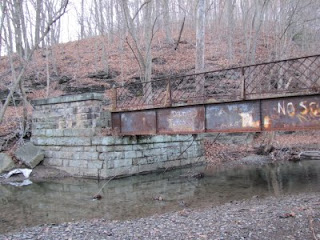
We have had toll roads for a long time. Northern Pike being one of them back in the very old days almost going back to the Revolution. Pikes were so named for the heavy swinging log used to block the entry. When you paid they turned the pike to let you on the road. These things were often privately owned. The Northern Pike bridge ceased to be used when the Union Railroad was put in back in 1902. That bridge probably goes back to the 1860s or 1870s. I will do a post some time on it. I have a lot of personal history with that bridge as a kid.
ReplyDeleteThe islands have camps on them and flooding is a fact of life. We do have some pretty good flood control dams in the area so I don't think it happens all that often. Another topic for a post.
Well retirement is proving to be rather nice. However the clocks are staying in weekend time. They are running twice as fast a work time. At this rate I will be dead in no time flat. I must find a way to slow them down.
A glorious post! Bridges are among the most marvelous creations of mankind as long as they don''t collapse with vehicles on them that were simmply traveling from shore to shore. We here in the Twin Cities still talk about the dramatic collapse of one of our major bridges a few years ago. Our county hospital has one of the best ERs in the country, so medical care was there when needed. All I know is I would not like to be dumped into the Mississippi from on high. Your phrase "not structurally sound" makes me nervous.
ReplyDeleteThe Army Corps of Engineers did some amazing lock building in Chicago before 1900 to reverse the flow of the Chicago River. The idea was to prevent additional pollution of Lake Michigan. Milwaukee was not as concerned and polluted like crazy until Chicago sued.
The daughter of the Chief Engineer of the Golden Gate and I taught at the same school. I don't have a list of birds, but I do have a list of bridges I've spent hours and hours memorizing.My favorites: the Golden Gate and the covered bridge in Ada, MI. I particularly like the Golden Gate when it seems to puncture the fog rolling in from the sea. The covered bridge looks about two inches long and connects two folksy parts of what is no longer a folksy village. More photos!
And congratulations on the Carnegie discovery.
When one likes bridges -- and libraries, the name Carnegie has special meaning.